Two main roads wend their way into the north western mountain area: the latter part of the trip offers good views, but the roads are poor and the twelve-hour journey is tiring. For most visitors, overnight train travel to Lao Cai and by road to Sapa is the best option.
The original Lao Cai town was destroyed during the 1979 invasion of Vietnam by the Chinese Army. As none of the present buildings predate the event, the only attractions for visitors is the road to Sapa and the border gate with China
Sapa came into existence as a hill station during the French occupation. Previously a Black H’mong village, it was ‘discovered’ early in the twentieth century and developed as a resort for French military officers, civil servants and business people. Its marked similarity to alpine areas in France and its temperate climate made it a haven from Hanoi's clammy winter dampness and sultry humid summer. By 1940, it was a sizeable town populated almost entirely by French citizens.
 |
|
As France’s grip on the country weakened, the buildings emptied. After their victory at Dien Bien Phu, the Viet Minh demolished most of the buildings. One that escaped was the summer residence of the Governor General of Indochina, which was commandeered by the Secretary General of the Vietnamese Communist Party as his holiday retreat. That was also flattened during the 1979 Chinese invasion. Today, a few buildings have been restored, notably the church, shelled by the French as the Viet Minh began to advance through the northern mountains. Several of the new buildings are vaguely based on the long gone French villas – the Auberge Hotel is a good example. |
Apart from that, the only enduring memento of the French presence is the inclusion of open fires and chimneys in many buildings – a welcome addition as the temperature often slips below zero in winter. Sapa has several reasonable local hotels, and one of international standard. A recent arrival is a small four-room guest house owned and managed by the Hoa Sua organisation. It’s comfortable, friendly and puts money into the local economy.
The ethnic minority groups
The main attraction of this area, apart from its superlative natural beauty, is Vietnam’s largest concentration of ethnic groups. Many distinct groups live in this area and, apart from those living around the tourist centre of Sapa, their dress, buildings, traditions and lifestyles have changed little over the last hundred years.
Cat Cat Village is about 1 km from Sapa town. It's located at the bottom of the Muong Hoa Valley and near the stunning Cat Cat Waterfall. Cat Cat is home to the Black H'Mong who accounts for over 50% of Sapa population. To visit village, you walk through Sapa Market down the valley. Once you walk out of the crowd, you'll be stunned by the nature's beauty with high mountains of over 3000 m and the green rice terraces dropping nearly 1000 below. The sun shines across and there are H'Mong houses scattered in the valley. The walking tour of the whole loop would take you about 2 hours.
Lao Chai and Ta Van Villages are home to the Giay People and Black H'Mong People. They are at the bottom of the Sapa Valley and offer breathtaking scenery of rice terraces dissected by the running water of the mountain streams. To visit these 02 villages, you'll need to hire a jeep or a motorbike and travel past the stadium and Sapa market gate. You'll follow this main road for 8 km, then you'll see a path down the valley to the right where you'll get off and start the walking trip of Lao Chai and Ta Van Villages. The whole tour takes about 1.5 hour.
Ta Phin Village is 12 km from Sapa Town and it's home to the Red Zao People. The village nestles itself on the mountain slopes and offers unreal mountain views. You can take a motorbike/jeep from Sapa to the village and enjoy a walking tour around chit-chatting with the local young girls selling handicrafts. Very likely you'll be invited to visit their home. The tour takes about 1-1.5 hour.
The Silver Waterfall and the Gateway to Heaven: these 02 sites located about 15 km from Sapa Town on the road from Sapa to Lai Chau province. The Gateway to Heaven is Tram Ton Pass between Sapa and Binh Lu town which offers stunning panoramic view of the Fansipan and the deep valley below. The trip takes 2 hours by jeep or motorbike. Make sure the camera has enough memory for this route.
Ham Rong Mountain is just right in the center of Sapa Town. The mountain offers a panoramic view of Sapa and its surroundings including Fansipan - the Peak of Indochina. Accessing the mountain, you'll go alongside the church from the town center to the end of the road and turn left for the asending path. There are steps which will guide you through the fresh orchid gardens and flower gardens to the top. There's also an ethnic house on the mountain with ethnic music and performances played by the local girls and boys.
The FanXiPan: represents the biggest natural reserve in Vietnam: HoangLienNational Park. The park covers nearly 30,000 hectares and is unique in all South-East Asia for its tiered forest ecosystems. It contains over 2,000 plant species and about 500 animal species, among which the black gibbon, of which there are only a few families left.
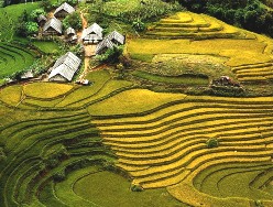
Two other features of the landscape immediately attract the visitor’s attention: the paddy-fields tumbling down the slopes in vertiginous staircases and the innumerable limestone peaks and crests emerging from the clouds in the morning, a sort of HalongBay transferred to the mountains.
The terraced paddy-fields: are built by the Hmong and Dao on the slopes where the water supply is sufficient to provide irrigation throughout the growing season. It takes a tremendous amount of work to create and maintain the paddy-fields and, in the absence of all instruments, it requires an elaborate ancestral technique, already used by the Chinese peasants before they emigrated during the second half of the 19th century. The surface area of the projected terraces is calculated according to the available water-flow. All the terraces must be perfectly horizontal, so as to maintain a constant water level before they pour into the terrace immediately below.
The fields of steep limestone peaks, usually covered with thick forests, are the result of the dissolving action of rain-water on limestone. The brown or red earth found at the foot of the peaks is the residue of this dissolution, the fertile «terra rosa» used by the peasants despite the numerous rocky residues mixed with it. The local populations clear and exploit the forests and find there many useful food and pharmaceutical products as well as raw material for handicrafts.
 |
|
The Markets:
Bac Hà market: The biggest ethnic market in the Lao Cai province, where you will find buffaloes, horses, blacksmiths, saddlers, but also traditional medicine doctors, with their thousands of mountain herbs and plants, and lots of traditional clothes and local artefacts. Several groups of deep-coloured Hmong are found there, as well as Dao, Tay, Nung, and Phu La. Make sure to arrive before 9 a.m., the market ends at about 12 :30. Sleeping in Bac Hà, on the Saturday offers an opportunity to watch the preparations for the market and the successive waves of villagers going there. Tasting the local corn spirit is a must, but be prudent, it may be up to 55° proof! |
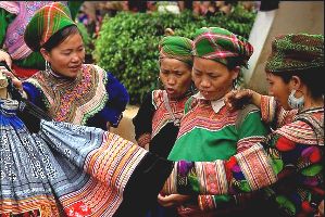
Can Cau market: Every Saturday from 6 a.m. to 12, in the middle of the paddy fields and corn fields, the various hmong groups from the highland villages sell their farming products and buy fabrics, farming tools and kitchenware. The local Hmong wear traditional costumes that are so gaudy and heavily embroidered that the Chinese, the French and the Vietnamese have nicknamed them the (Flowery Hmong). Numerous Hmong farmers travel back to their villages on horseback, the only way to carry heavy loads in these steep areas.